Between 66 and 125 million years ago, dinosaurs roamed Texas. There are several places where you can see real dinosaur tracks, including the popular Dinosaur Valley State Park.
But, I was excited to find out that you can see dinosaur tracks in the San Gabriel River bed in Leander, just north of Austin. When I say the tracks are in the river bed, they are literally in the river, and you have to take a short hike to get there.
Here’s what you need to know to make the most of your dino track exploration.
1. There is no official parking for the site, in fact the site isn’t a park or anything, it’s just part of the San Gabriel River. So, you have to find a good spot to park. I’ve seen folks in trucks park under the bridge near the river, which I suppose you could try if you have a 4 wheel drive vehicle. But, what I do is set the GPS for 601 S. Gabriel Dr, Leander, Texas 78641. This is a maintenance station for the phone company. I’ve never seen a phone company worker or vehicle here, and the area is fenced off. But, I park just inside the fence, and off to the side to make sure anyone on official business can get through and I’ve never had a problem.
2. After parking, you have to hike back under the highway to the river. It’s a pretty easy hike but parts are steep and can be muddy if it has rained so wear good shoes and sunblock if it’s sunny outside.
3. I’ve never seen a snake here, but the brush and grass along the river is overgrown and I wouldn’t be surprised if snakes are in there. Keep your eyes open!
4. The hike is about a mile from the bridge (I haven’t measured it, that’s a guess) and will seem farther because the going is kind of slow. It’s not difficult, it’s just that you have to navigate the riverbank. It takes a bit of time. You’ll know you’re getting close when you can’t see the bridge anymore.
5. VERY IMPORTANT The San Gabriel river, like many rivers in central Texas, has a limestone floor. That’s why the dino tracks have been preserved for millions of years. BUT, that also means that the river is prone to flooding. If it’s raining, don’t go. If the river is flowing fast, don’t go. If the water level is high, don’t go. The tracks are in the river, so if the water level is high you won’t be able to see them anyway. And, make sure you bring a charged cell phone. I rarely see anyone along this part of the river, so if you get in trouble, you may be on your own.
6. Speaking of the river’s water level, the best time to go is in the summer when there hasn’t been a lot of rain. That’s when the river level is at it’s lowest and the tracks are easiest to see. Like I said, the tracks are in the river (though near the edge, not in the deepest part) so a low river level helps you to see the tracks. And, if you go during the right time, the tracks may not be covered in water at all.
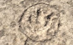
7. The tracks are not marked except for a few that have been circled with what looks like spray paint. It pays to keep your eyes open, but you’ll know the tracks when you see them.
Happy Hunting!
About the Author

Brent Petersen is the Editor-in-Chief of Destination Eat Drink. He currently resides in Setubal, Portugal. Brent has written the novel “Truffle Hunt” (Eckhartz Press) and the short story collection “That Bird.” He’s also written dozens of foodie travel guides to cities around the world on Destination Eat Drink, including and in-depth eating and drinking guide to Portugal. Brent’s podcast, also called Destination Eat Drink, is available on all major podcasting platforms and is distributed by the Radio Misfits Podcast Network.